River’s quiet warning

- Update Time : Monday, March 16, 2026
- 26 Time
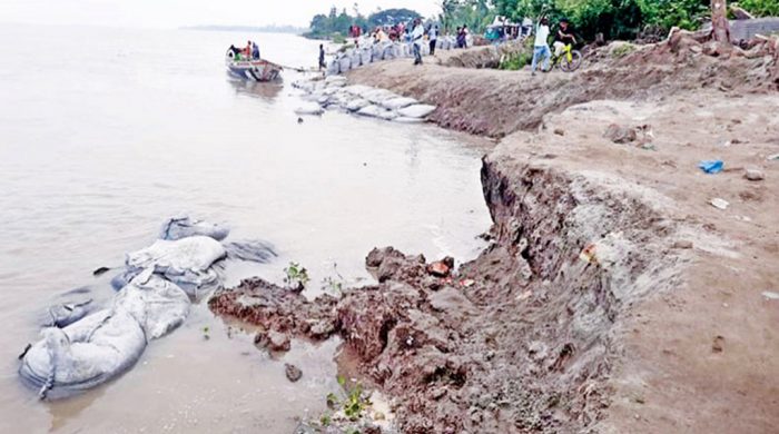
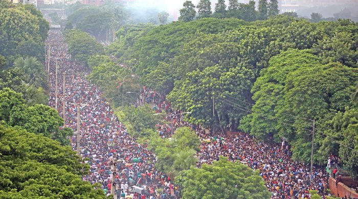
A VISIT to the River Jamuna near Sirajganj offers a striking and unsettling picture of the fragile river landscape. Beneath the bridge, the river appeared unusually shallow, its vast bed exposed and layered with sand. Yet, along other stretches of the riverbank, water crept dangerously close to human settlements. Houses that once stood at a safe distance now face the river at their doorstep. What appears to be a sudden encroachment is, in fact, part of a deep and more complex transformation unfolding within one of the most dynamic river systems.
For communities living along the Jamuna, riverbank erosion is neither an abstraction nor a distant environmental concern. It is a recurring reality that erases homes, farmland, trees and livelihoods in a matter of days. Villages disappear, families relocate repeatedly and agricultural land is swallowed by the shifting current. Yet, these dramatic losses are not merely seasonal disasters. They are manifestations of long-term geomorphological processes in which rivers continuously reshape land through sediment transport, channel migration and char formation.
The sand-filled channel observed near Sirajganj shows this dynamic clearly. In large braided rivers such as the Jamuna, enormous quantities of sediment flow downstream from the Himalayas. This sediment settles unevenly across the riverbed, creating new landforms known as chars. While chars sometimes appear to offer new land for cultivation and settlement, they are inherently unstable. Research suggests that roughly 12 million people in Bangladesh live in char areas, which together account for about six percent of the country’s land. Yet these lands may emerge and disappear repeatedly as river channels shift and sediment distribution changes.
The imbalance visible in the Jamuna’s riverbed reflects this constant redistribution of sediment and water flow. In some places, sediment accumulation raises the riverbed and reduces water depth. In others, powerful currents erode riverbanks and carve new channels. The result is a widening river and intensified bank erosion, a pattern that has become increasingly evident across several major rivers.
Seasonal dynamics further amplify the problem. Riverbank erosion typically peaks during the monsoon months, particularly between June and September. Surveys indicate that the overwhelming majority of affected communities experience severe erosion between July and October, when strong currents weaken riverbanks and trigger sudden collapses. Each year rivers in Bangladesh consume an estimated 10,000 hectares of land. Research in erosion-prone areas shows that more than 70 per cent of houses have been destroyed and over 80 per cent of affected residents have experienced displacement. These figures show that erosion does not simply remove land; it destabilises entire social and economic systems.
Agriculture suffers the most immediate and lasting damage. Paddy fields account for the majority of lost or damaged cropland in erosion-prone areas. When fertile soil is swallowed by rivers or buried under thick layers of sand, farmers lose not only land but their primary means of livelihood. Many are forced to abandon farming and seek work as day labourers or migrate to cities. Over time this process deepens rural poverty, undermines food security and intensifies social vulnerability.
To understand why this cycle persists, the broader geomorphology of the Bengal Delta must be considered. Scholars have for long argued that the delta is not a fixed landmass but an evolving landscape shaped by sediment deposition and subsidence. Vast quantities of sediment carried from the Himalayas have built the delta over thousands of years. At the same time, newly deposited land gradually sinks under its own weight. This constant interplay between sedimentation and subsidence allows rivers to change course, creating new channels while abandoning old ones.
In this context, channel shifting and erosion are not anomalies but natural characteristics of deltaic rivers. The Jamuna’s current behaviour, including sediment accumulation in some areas and severe erosion in others, reflects this ongoing delta-building process. The problem arises when human interventions and climatic changes disrupt the delicate balance that governs these systems.
Climate change is already altering rainfall patterns and intensifying monsoon variability across South Asia. Sea-level rise is placing additional pressure on low-lying delta regions. Meanwhile, upstream dams and water control infrastructure can alter sediment flows and river discharge patterns. When sediment supply is reduced in some locations and concentrated in others, river channels may reorganise more abruptly, increasing erosion risks.
Human activity within Bangladesh also contributes to this instability. In many areas fertile soil from chars is illegally excavated and sold, weakening riverbanks and accelerating erosion. Such practices remove natural barriers that would otherwise help stabilise the landscape. Combined with shifting hydrological patterns, these interventions can magnify erosion far beyond what natural processes alone would produce.
Recent field reports suggest that this instability is now beginning to affect critical infrastructure as well. Even before the peak monsoon season, abnormal erosion has been observed along sections of Jamuna and Padma riverbanks. In the Jajira region of Shariatpur, for instance, erosion threats have appeared near protective embankments associated with the Padma Bridge project. When riverbeds deepen and currents concentrate against embankments, the risks extend beyond villages and farmland to large-scale state infrastructure.
The consequences of erosion therefore extend far beyond the immediate loss of land. Each year thousands of displaced families migrate toward urban centres, particularly Dhaka, in search of shelter and work. Many end up in informal settlements where housing, sanitation and employment opportunities are limited. Riverbank erosion thus evolves from a rural environmental crisis into a broader urban governance challenge, placing additional strain on already stretched city services.
Legal uncertainty compounds the hardship faced by erosion-affected communities. In many cases chars reappear years after land has been washed away. However, under long-standing legal frameworks governing alluvion and diluvion, newly emerged land may be classified as state property if it remains submerged for extended periods. As a result, families who once owned land may struggle to reclaim it when it resurfaces. Bureaucratic obstacles, disputes over ownership and attempts by local powerholders to occupy emerging chars often create a second layer of dispossession for already vulnerable communities.
Addressing these challenges requires a shift in how river management is approached. Large-scale embankments and bank protection structures alone cannot provide lasting solutions. Rivers within delta systems are inherently mobile, and attempts to fix them permanently in place often lead to unintended consequences elsewhere in the system.
Integrated delta management offers a more sustainable path. Scientific dredging and channel management must be carried out in ways that maintain balanced sediment distribution rather than simply redirecting flows. Floodplains should not be entirely isolated from river systems; controlled flooding allows sediment to replenish soil fertility and maintain natural land-building processes.
Equally important are social and economic measures for communities living in erosion-prone areas. Planned resettlement programmes, secure land rights for char residents, access to low-interest credit and alternative livelihood opportunities can reduce the vulnerability of those most exposed to river instability. Continuous monitoring of river courses, sediment patterns and bank erosion is also essential for anticipating future shifts.
Ultimately, the challenge is not to eliminate river dynamics but to adapt to them. The Bengal Delta has always been shaped by the interaction of river, sediment and sea. Efforts to impose rigid control over these processes often lead to greater instability. Sustainable planning must therefore recognise that living in a delta requires flexibility, scientific understanding and long-term adaptation.
The shallow, sand-filled channel observed near Sirajganj is more than a local curiosity. It is a visible signal of the complex forces reshaping Bangladesh’s rivers. As sediment flows redistribute and channels adjust, the consequences ripple outward — through agriculture, settlement patterns, infrastructure and legal systems. Riverbank erosion is not simply a seasonal calamity; it is part of an ongoing re-organisation of the delta landscape.
Recognising this reality is essential for building policies that protect both people and the land they inhabit. In a country defined by rivers, stability is never permanent. The task is not to resist the river’s movement entirely, but to understand it and to learn how to live with it more wisely.